
Serving Proudly As The Voice Of Valley County Since 1913
Serving Proudly As The Voice Of Valley County Since 1913
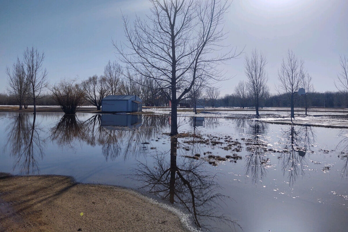
Warm Temps And Precip Caused Rivers To Rise Quickly
Rapid snow melt at Sullivan Park has caused parts of the park to be underwater. As weather conditions continue to stay warm and dry, the National Weather Service in Glasgow is expecting a 50/50 chance of the Milk River reaching moderate flood stage.
The National Weather Service in Glasgow held a flood briefing earlier today, April 13, to discuss the current weather conditions as well as what to expect from flooding.
Today's rain/snow event saw a half to 3/4 inch liquid precip with less than 2 inches of snow in the Valley with chances for over 6 inches in northern Valley County. A rapid warmup over this past weekend caused rivers to rise very quickly with many basis along the Milk River experiencing Major flooding as of April 13.
Conditions for the next few weeks will be cooler than normal which will slow any additional melting, but expecting above-normal precipitation, which likely will keep current flooding concerns higher for longer and could possibly cause rivers to rise even higher.
The Milk at Tampico is expected, as of April 13, to crest just below record flooding, but could surpass it with continued melt and precipitation over the next week. The river has already reached a level that would put it at the fifth highest on record. The current record of 28.03 ft at Tampico was recorded in April of 2011. The forecast is for Tampico to crest around 27.8 ft by early next week, which would put it at third highest all time if the forecast remains unchanged.
Glasgow is expected to crest near 32 ft, which is about 1 foot below the crest in 1952, and 2 feet below the crest in June of 2011. If Glasgow does hit 32, it would be the first time it has hit that since 2011. Current forecast, if unchanged, would bring the Milk in Glasgow to the 13th highest crest on record, and would need to surpass 32.50 ft to break into the top 10.
For Nashua, the forecast has the Milk cresting at 27.4 ft early next week, which would be the highest since 2019 and would put it at 9th highest on record. The current record stage for Nashua is 31.38 ft, which was set during the 1952 flooding.
For the latest forecast updates, visit weather.gov/glasgow. If you have questions or would like to submit weather reports or photos email [email protected] or call 406-228-9622.
*The below information is from the story that was published in the April 12 issue. The information has since changed since publication.
Key Valley County, Roosevelt County, Glasgow and Nashua stakeholders as well as members of the Army Corps of Engineers and Montana DES convened at the National Weather Service in Glasgow on April 6 to hear about how the recent warm-up in temperatures will affect area streams, creeks and the Milk River.
As of press time, Flood Warnings were issued for Beaver Creek near Hinsdale with minor flooding forecasted as the crest was expected to rise to 14.7 feet Monday afternoon and then fall below flood stage by Tuesday evening. There were also reports of flooding on the Larb Creek south of Beaverton, which is on the Phillips and Valley County line, on the Billingsley Road due to Antelope Creek flooding and water over the road on the Fort Peck Highway near Maxness and Duck Creek roads. Though no road closures have been reported as a result of the water on roadways, the conditions can quickly change. When seeing flooding on the roadway, make sure to turn around and find an alternative route to your destination.
According to the National Weather Service (NWS) in Glasgow, the current spring-like conditions are here to stay for the foreseeable future with chances of rain at the end of the week. The NWS is expecting less than a quarter inch of rain to fall within Valley County later this week, which could lead to small creeks and streams running higher than normal. The Milk River shouldn't be significantly affected with the rain fall though. Due to the average temperatures, the snow pack has been able to melt off slowly enough where the area won't see major flooding even with the addition of the rain.
When reviewing the models, the National Weather Service believes there is a 100 percent change of minor flood stage on the Milk River in Glasgow, which is 25 feet, with 50 percent chance of Moderate Flooding and a less than 10 percent change of reaching Major Flood Stage. Low-lying farmlands along the Milk River can expect some flooding at the 26 feet height. The back trails of Sullivan Park will also see flooding around 26 feet with the baseball fields flooding at 29 feet.
The main areas the meteorologists at the National Weather Service are keeping an eye on along the Missouri River and all basins across northeast Montana. While the reach of Milk River near Malta does not pose any flooding potential at this time, they do expect increasing risks for flooding between Saco and Glasgow. North to south-flowing creeks that feed into the Milk and Missouri Rivers will be at higher risk for flooding, which has already been seen, including at Beaver, Whitewater, Frenchman, Big Muddy Rock, Cherry and Poplar all being of concern and will be watched closely.
Though the winter seemed like it last forever, the amount of snow that fell was not a record-breaking amount of snow, as it was about 40 inches less than the record breaking season of 2010-2011. Glasgow did have its first high of 50 or higher on April 8 with a high of 51. The last time the area reached 50 degree was Nov. 5, 2022 and ended a streak of 154 days of high below 50 degrees.
For the latest forecast updates, visit weather.gov/glasgow. If you have questions or would like to submit weather reports or photos email [email protected] or call 406-228-9622.
Reader Comments(0)