
Serving Proudly As The Voice Of Valley County Since 1913
Serving Proudly As The Voice Of Valley County Since 1913
Valley County Gets Hit With Mother Nature
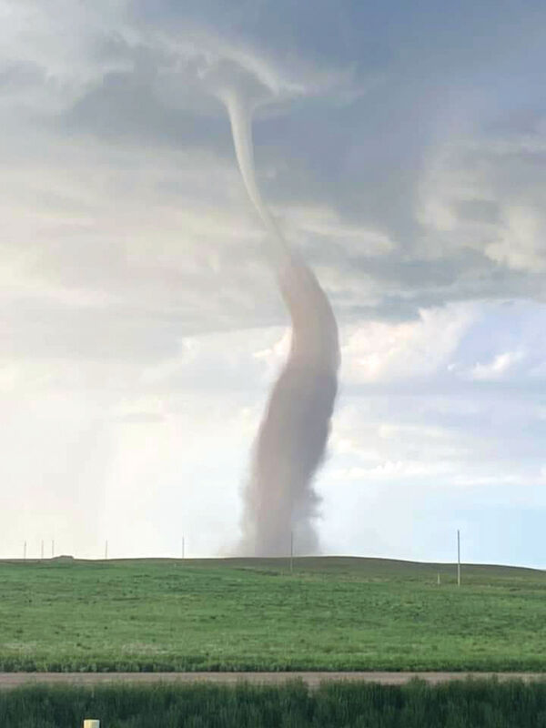
During the severe weather on June 1, this tornado was seen a few miles north of Ossette Road in northeastern Valley County.
Mother Nature made her presence known in more ways that one over the last week with severe thunderstorms, flooding and a tornado.
After many reports of tornado sightings the evening of June 1 on the Valley and Daniels County border, the National Weather Service (NWS) in Glasgow confirmed a landspout tornado occurred near Lustre. A storm survey team from the Weather Service went out to the area and did not see any visible damage to property or fields. There was also no report injuries. As a result the landspout lead to an EF Rating of Unknown, which occurs when there is evidence of a tornado but no damage.
The Weather Service did classify the tornado as a landspout due to the spin up being a result of outflow boundaries converging in the area.
The following day saw continued heavy rain and hail threats. The rain was so fast and heavy that Highway 2 was closed west of Glasgow with Valley and Phillips County due to floodwaters flowing across the highway. Valley County also experienced road damage and flooding on parts of Beaverton Road, Larb Creek Road, Kirwin Road, Willow Creek Road and Vandalia Road well into June 3 and 4.
Along Highway 2, drivers have also seen sections of the railroad bed washed out leaving portions of the track suspended in the air.
As of press time some of the roads and track were impacted by the flooding with road crews directing traffic away from the affected areas.
After being flooded earlier this year, the Milk River at Glasgow is back at minor flood stage, which made this past weekend's Catfish Classic all the more interesting for anglers. The River is expected to remain at or near minor flood stage through at least Thursday afternoon, which at that point the levels is expected to gradually recede.
Mother Nature will give the area a little bit of a break as warm weather is expected this week with afternoon thunderstorms again expected by midweek. The NWS states high water on area creeks, streams and rivers will begin to subside with the drier conditions early in the week, but the potential for heavy rain again late in the week, could bring water levels back up.
For the latest forecast visit http://www.weather.gov/ggw/.

Reader Comments(0)