
Serving Proudly As The Voice Of Valley County Since 1913
Serving Proudly As The Voice Of Valley County Since 1913
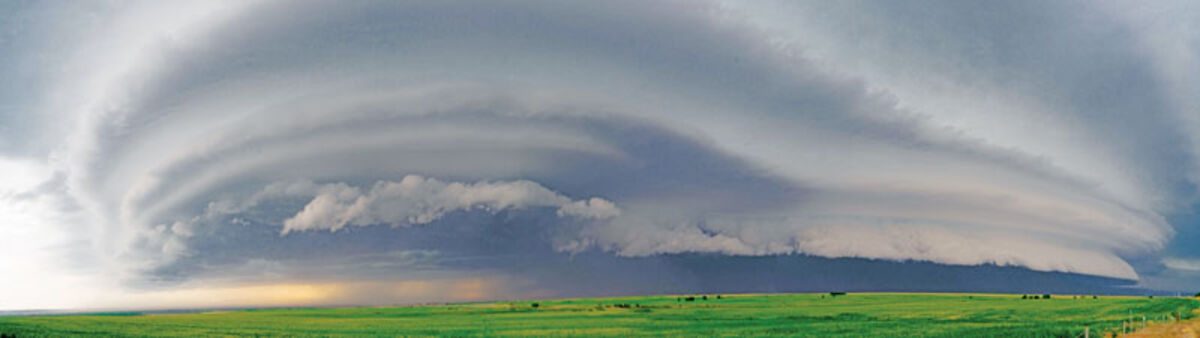
A supercell thunderstorm looms over Roosevelt County July 10. This storm raged from just west of Malta into North Dakota and followed one day after a macroburst thunderstorm struck Plentywood, Mont.
A two-day bout of severe weather July 9 and 10 has prompted concerns from the National Weather Service in Glasgow that many northeast Montana residents may not be aware of severe weather alerts. According to Chief Meteorologist of the NWS in Glasgow Tanja Fransen,, the only automatic alerts sent to cell phones are tornado and flash flood warnings.
Fransen told the Courier that in the case of last week's storms, the macroburst thunderstorm in Plentywood was warned due to the threat of a tornado, but alerts for the July 10 supercell thunderstorm that occurred from Malta to the North Dakota border would not have reached everyone. Those alerts would have only reached individuals with National Oceanic and Atmospheric Administration (NOAA) radios, those listening to local radio or those who had downloaded the Federal Emergency Management Agency (FEMA) or Red Cross cell phone applications.
"They only matter if people get them," said Fransen discussing the severe weather alerts issued prior to the thunderstorms. On July 9, the NWS had issued a severe thunderstorm warning 30 minutes prior to the event and had issued a tornado warning 16 minutes prior to the event. According to Fransen, the national average for tornados is approximately 12 minutes lead time.
That also means that those receiving severe thunderstorm alerts had 14 extra minutes to prepare for the storm and seek shelter. Those only receiving tornado warnings had less than 16 minutes to prepare for severe weather.
Fransen stressed the importance of receiving all NWS messages and preparing for severe weather before it happens. She also stressed that the safest place is indoors. If no shelter is available or if given the choice to be in a recreational vehicle or a regular-wheeled vehicle, it is safer during thunderstorms to be in a car or truck. Fransen explained that the lower profile means it is less likely to be lifted or moved by high winds.
In the case of the severe storm in Plentywood, Fransen said the event was a million dollar event, and she said, "An event of that magnitude occurs every year." The Plentywood storm was unique in that a large macroburst thunderstorm occurred simultaneously to an F1 tornado, causing large amounts of damage from both straight line winds and rotational damage from the tornado.
According to Fransen, a macroburst occurs when a storm loses upward force and is unable to maintain lift. The result is the entire storm collapses to the ground at the same time. In the event of a macroburst the size of the cloud is over 2.5 miles across. Wind speeds during a macroburst can exceed 100 miles per hour and can cause severe destruction to buildings and vehicles.
On July 9, the storm in Plentywood destroyed a total of 10 aircrafts and eight buildings while also damaging another six buildings. Another result of the storm was the decimation of the airport beacons as well as NWS cameras and computer monitoring equipment.
According to Fransen, most cell phones can receive severe weather alerts they just need to change the settings. On most Android phones from the home page of the app, scroll to the right along the bottom, click on Settings then on the Settings menu, click on severe weather alerts then select from most severe, moderate severe, or all alerts.
On other Android phones that can be done under Settings, Connections, More Connection Settings, Alerts, and turn all alert settings to on. On iPhones Open Settings, tap on Notification Center, scroll all the way down to the bottom and tap on the toggle switch next to emergency alerts.
For more information contact 228-4042 or go to weather.gov/ggw.

Reader Comments(0)