
Serving Proudly As The Voice Of Valley County Since 1913
Serving Proudly As The Voice Of Valley County Since 1913
NWS Marks High Water Level At Sullivan Park
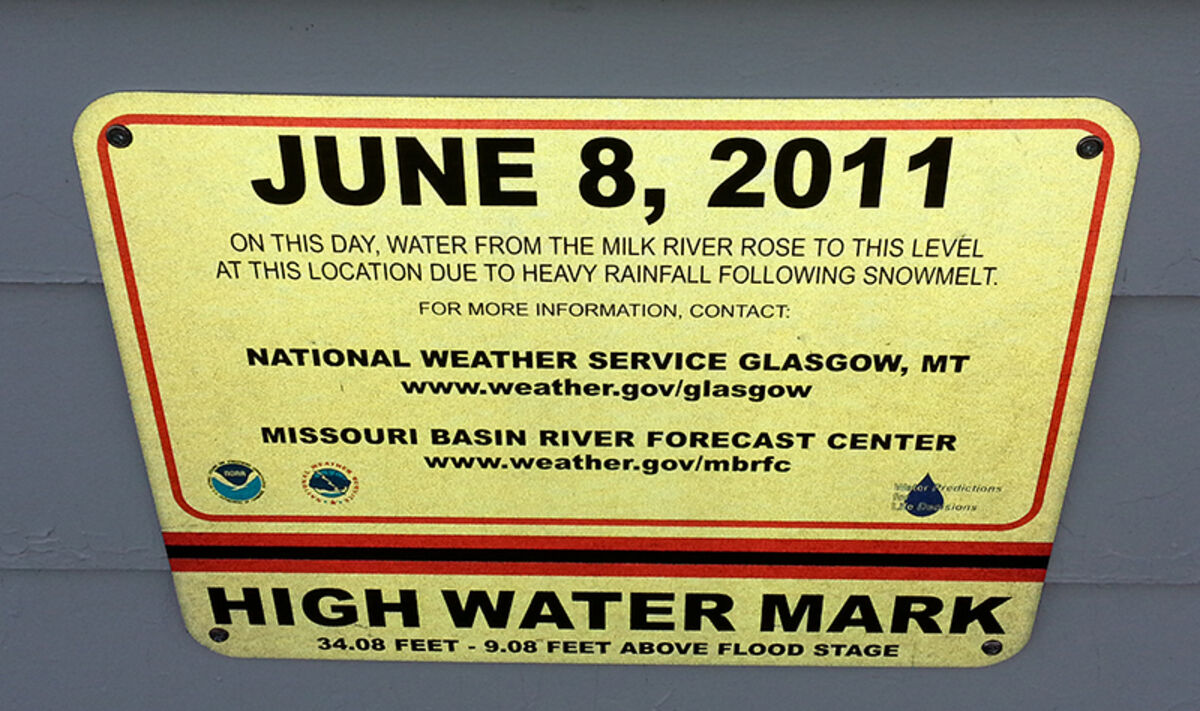
A painful but important reminder was placed at Sullivan Park this week. The National Weather Service in Glasgow worked with the Glasgow Reds baseball team to place a high water mark on the concessions stand.
Valley County and the city of Glasgow will never forget a flash flood that took everyone by surprise on June 8, 2011. Tanja Fransen, a local meteorologist at the National Weather Service, said they placed the water line mark in a place where more people would see it.
"The marker is for anyone in the future to see," she said. "Twenty years from now people can go by and realize that this happened here. It was an event I'll never forget."
The placement of the marker made more sense at Sullivan Park then at the bridge where the measurement was taken. Fransen explained that several people would drive by the park during the flooding to figure out where the water was over a three-month period of time. The park was under water from April through June in 2011.
The 2010-11 year brought in record snowfall. There is an average of 30 inches of snowfall in a year – and that particular year dropped just over 108-inches of snow. The snowmelt caused excess runoff but the water receded. The problems began in May, when more than 10-inches of rain fell. Fransen said the average rainfall is 11 inches in a year. More rain accumulated in June – and between four and five inches fell on June 7, which caused the water levels to rise.
In 2011, Glasgow recorded the wettest, and highest river record, as well as the most snow fall. Fransen said that the new water line will help remind people of the possibilities when they build in the flood plain. While many in the area were educated on the rising waters, a lot of livestock and horses were moved before the waters swept in.
"It wasn't a total sock in the area, but we couldn't predict the flash flood," she said.

Reader Comments(0)